Route Library

Want to get a flavour of our rides? We’ve put together a list of some of our favourite routes. Whether you’re visiting York and want to see the best bits, or a regular roadie who wants to bank some time on the bike - there’s something here for you.
All routes start and finish at Cycle Heaven on Hospital Fields Road. We’d strongly recommend their cafe, The Cyclist - it’s a great place for a pre-ride coffee or a post ride slice of cake (or both!)
From a flat 20 mile roll out of the city to a super challenging Imperial century - we’ve got you covered. These routes will allow you to explore York and showcase some of our favourite parts of the beautiful place we call home.
20-ish Miles

"Tea by the Lock"
Toilets: Tea by the Lock (café)
Café: Tea by the Lock
Cross over Millennium Bridge and turn left on Bishopthorpe Road. Turn right on to the cycle path through the Knavesmire, through parallel to the the A64 and on to the Solar System cycle path. Follow the Solar System down to Escrick. Take the turn off and turn right on to Escrick Road. Turn right at the Cross Key’s Inn down Church Hill. Follow this road all the way down to Naburn. Watch out for the sign posts for Naburn Locks - Tea By The Lock is where you’ll find your cafe stop.
After you’ve enjoyed your well earned slice of cake and an invigorating coffee, retrace your steps back on to the B1222 and turn left - heading towards York. Turn right on the Howden Road to return to the Solar System to cross the river past the Fisher of Dreams sculpture. After you’ve crossed the river, drop on to the Acaster Lane heading towards Acaser Malbis. Follow the route down the Ouse and round to right past the Ship Inn, turn right when you reach the junction at Mill Lane.
On the home stretch now, a right turn on Darling Lane will lead you up to the big right turn on Acaster Lane leading into Bishopthorpe. Go through the village over the A64 via the overpass, and past the Knavesmire on to the Bishy Road. Down to the Village Spice restaurant where you’ll turn right back on to the Millennium Bridge and home.
Distance: 18.2 miles (29 km)
Elevation: 371 ft (98 m)
Difficulty: 2/10

Cross over MIllenium Bridge and turn left on Bishopthorpe Road. Turn right on to the cycle path through the Knavesmire, taking the Sim Balk Lane up and over the A64. Turn right on the Appleton Road and follow it down to the junction and turn right on Broad Lane. When you reach Appleton Roebuck, turn left on Old Road. Cross over the train line and follow the road down until you reach D’Oyly’s Tearoom on your right hand side.
As you set off on your return, you’ll retrace your steps back up Old Road and back over the train line. Take the next left down New Road, running adjacent to the train tracks. Turn left at Colton Lane, back over the train lines. Make sure to take the right turn at Bilborough Top to go over the A64 safely, turn right after the over pass to head into Bilborough itself. Follow this road round to the right, and then turn left at the end of the road. A right turn on the York Road to take you down to Askham, where you’ll turn left. When you reach Askham Bryan turn right on to Main Street and follow it down back towards town. As you come up to the main roundabout look out for the cycle path on your right hand side - this is the safest way to navigate across the A1237 and through on to Moor Lane. This will take you up to the big Tesco on the Tadcaster Road, from there is a left turn and back into town.
Distance: 20.1 miles (32 km)
Elevation: 321 ft (98 meters)
Difficulty: 2/10
30-ish Miles

Straight down the Fulford Road before taking a right to go round the back of the Designer Outlet and on through Naburn. As you leave the village take a left on to Moor Lane and follow this narrow road all the way to the A19.
You're aiming for the village of Escrick so take a right on to the road - or more sensibly the bike path and make your way to the left turn into Escrick from there. Leaving Escrick you're looking to take a left turn for Wheldrake. Once you reach the village Wheldrake take a left at the Wenlock Arms and head along Greengales / Wheldrake Lane towards Elvington.
Take a right at the junction and go through Elvington, over the river, and on to and through Sutton-upon-Derwent. Once you've crossed over Pocklington Canal (via a traffic-lighted bridge), you'll go around a sweeping right-hand bend before approachin ga sharp left-hand bend. It's here you need to take a right (signposted Storwood and E Cottingwith - there may even be a brown caravan sign as well). Once on this road, take the first available right (just after the Storwood sign), and then right again at the next junction that will bring you to a junction very close to the Pocklington Canal again. Turn left here and you've completed your Tiny Loop.
You then retrace your steps all the way back to Wheldrake whereupon as you leave the village you stay on the "main" road and head all the way back to theA19 at Crockey Hill.
A right at the lights and then carefully make your way to, and across, the A64 before heading back up the Fulford Road to Cycle Heaven.
Distance: 29.8 miles (48 km)
Elevation: 538 ft (164 m)
Difficulty: 2/10

First stop is Haxby and you get there by way of James Street, Huntington Road and across to and up Haxby Road. From Haxby it's across to Strensall, a left at the Ship Inn and then on to pretty much (but not quite) Sheriff Hutton. Instead, take a right turn to go to West Lilling and another right in the village to take you the quiet way to Flaxton (ish). Head through Flaxton and on to the A64 for a very brief run (few hundred metres) and then a right to Claxton - take care here. From here navigate by villages: Sand Hutton, Upper Helmsley, Warthill and Murton before heading into Osbaldwick. From here it's a case of crossing the Hull Road roundabout by the petrol station, passing through Heslington and past Fulford Golf Club before heading up Broadway back to the Fulford Road. A right at the lights and then back to Cycle Heaven.
Distance: 30.4 miles (48.9 km)
Elevation: 726 ft (227 m)
Difficulty: 3/10

Start by heading for Heworth and then pretty much ride all of Stockton Lane to, through and beyond Stockton to Upper Helmsley and on to Buttercrambe. Just prior to Buttercrambe it's a left turn and head to Bossall. Once there it's a right a tiny (well, 5km) circle that brings you back to Bossall and loop one complete. From there it's on to Claxton, Sand Hutton and Upper Helmsley to close out loop two. You then retrace some earlier roads for a few km before turning left towards and through Warthill leading to the homeward leg via Murton and Heslington. When you get back to the lights on the Fulford Road that's loop three complete and ride done!
Distance: 30.7 miles (49.4 km)
Elevation: 926 ft (282 m)
Difficulty: 4/10
40-ish Miles

Heading for the Hull Road/A64 interchange first and we get there via Fulford Road, York Cemetery, Heslington Road and the Hull Road itself. Once beyond the interchange take the right turn and head through Elvington, Sutton and Melbourne before taking a left turn for Thornton. From here a coule of rights bring you back on to the Melbourne Road where you take a left for Seaton Ross and then on to Laytham before heading through various villages: Aughton, Ellerton, East Cottingwith and Storwood. This should bring you out at the traffic lights by Pocklington Canal, so cross the canal and head back through Sutton and Elvington before taking the left turn that takes you to Wheldrake. From Wheldrake it's back to Crockey Hill and then straight back up the A19 back into Fulford and on to Cycle Heaven.
Distance: 41 Miles (65 KM)
Elevation: 210 meters
Difficulty: 4/10

Down the Fulford Road towards the A64 before taking the usual right turn that takes you on to the Naburn Road and round the back of the Designer Outlet. Head all the way into Stilingfleet before turning right and on to Cawood. Left at the lights in Cawood followed by a straight on at the mini roundabout. This road takes you through Cawood and Wistow Commons before a T-junction sees you take a right and over the railway line to Thorpe Willoughby. A quick right and left combination - on to and off - the A1238 Leeds Road takes you through residential Thorpe Willoughby before another right at the end of the road puts you on Field Lane. Follow this all the way to the end and the mini cycle path before carefully crossing the A63. The cycle path quickly opens out to a proper road which sees you skirt the edge of Hambleton before heading south.
A right on to Hillam Road leads you to well, Hillam of course, before a right turn sees you heading into Monk Fryston. A very brief flirtation with the A63 before a right turn off it takes you to and through South Milford and on to Sherburn. A left at the traffic lights in Sherburn sees you go up the hill and then take a right on to Sir John's Lane heading towards Lotherton Hall. After the right / left turn into the small hill, take a right as it flattens out and head on into Saxton.
In the village take a left and head up to Towton Moor before descending back down to the A162 and Towton itself. From here it's all the way into and out of Tadcaster back towards the A64. Use the bike path here if you wish but you want the left turn immediately after the slip road on to the A64 heading to Catterton. From here head through Bilbrough and Askham Bryan before taking the third exit at the ring road roundabout and take the standard route back to Cycle Heaven via Moor Lane, Tadcaster Road , Knavesmire Road and Millennium Bridge.
Distance: 43 Miles (69.2 KM)
Elevation: 1170 ft (357 m)
Difficulty: 5/10
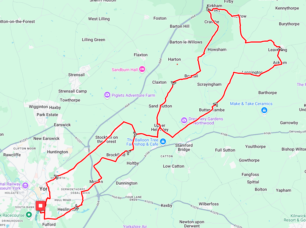
"Kirkham Abbey"
Toilets: Stamford Bridge (slightly off-route)
Café: The Balloon Tree near Stamford Bridge (slightly off-route)
One of the familiar routes out of the city via York cemetery, James Street, Heworth Green and Stockton Lane all the way through and beyond Stockton. A right at the end followed by two lefts sees you heading towards Upper Helmsley but a right turn is taken before you hit the "main" part of the village.
You then descend to the end of the road before taking a left and heading all the way to and through Buttercrambe (take care as you cross the bridge - it is a touch narrow). You then continue aong this road before takign a right (signposted Leppington). When you reach the end of the road take another right and head all the way into and out of Acklam and on to Leavening. A left here takes you out of the village where you will eventually hit a crossroads. Right here followed by the first left and you'll end up in Westow. Soon after the pub on the right take the left to head down and then back out (and very up) of Kirkham.
As the natural tree tunnel begins to fade you'll take a left to take you to Crambe and beyond (including a railway crossing) before a left-right-left combination has you heading into Bossall and on to Sand Hutton and Upper Helmsley to complete the first genuine loop. From here a small bit of back-tracking before you head through Warthill, Murton and into Osbaldwick.
A left on to Tranby Avenue takes you up to the A1079 roundabout. Straight over here before the classic return via Heslington and Broadway.
Distance: 39.7 Miles (64 km)
Elevation: 1657 ft (505 meters)
Difficulty: 6/10
50-ish Miles

This route is as flat as they come, heading south for a bit of an industrial tour of the Humber region. Leaving York through Naburn (hold your breath) towards Selby, followed by Camblesforth, you'll pass very close to Drax power station on some very quiet lanes. There is a brief stint on some bigger, but wide, roads on your way to Howden via the impressive Rawcliffe bridge.
There are several cafes to choose from in Howden: the one next to the church is a favourite. There's a nice square in the middle to congregate on a nice day if you can't decide. The return home is equally flat and quiet, weaving through some tiny lanes to Escrick, finishing on the planets bike path to Bishopthorpe.
Distance: 52.4 miles (84.3km)
Elevation: 630 ft (190m)
Difficulty: 4/10

A jaunt into the Howardian hills, leaving York under the ring road underpass and taking quiet lanes all the way to Hovingham. The hardest climb is Snargate Lane, which gets steeper towards the top. The remaining climbs are rolling and not too long.
There is an excellent descent into Hovingham to the cafe at the bakery, idyllically situated next to the stream: perfect for a sunny day. Return via the Monuments climb through Castle Howard, a careful descent of Bulmer bank, a couple more rolling hills and a flat ride home from Sheriff Hutton.
Distance: 50.3 miles (81km)
Elevation: 2100ft (640m)
Difficulty: 5/10

This ride features the aptly named Painsthorpe lane climb, which thankfully eases off after a steep start. It is rewarded with an excellent descent into Thixendale, an easy climb out the other side of the valley, and another awesome descent into Birdsall.
After passing through the posh villages of Langton and Westow, the cafe stop at Westow cricket club is basic but as cheap as they get. Don't eat too much here, as you have to climb up a steep road out of Kirkham Priory minutes out of the cafe, admiring the ruins on your way over the bridge. The steep climb is rewarded with another great descent and easy rolling roads back to York.
Distance: 52 miles (83.7km)
Elevation: 2860 ft (872 m)
Difficulty: 6/10